Introduction
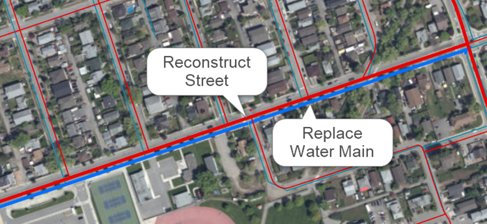
The Work Planner module for Predictor is an Esri ArcGIS Pro Add-In that offers infrastructure intensive organizations a flexible and user-friendly environment to bundle optimized output from Predictor into logistical projects. While designed primarily for people involved in developing capital investment plans, it can be used by anyone with a need to create and fund work plans across one or more asset classes. A common use-case is to combine a road reconstruction need with water-main replacement need within the same street.
Tools within Work Planner allow the user to select the assets involved in the project on the GIS map, establish the correct costs, phase the project, and allocate funding across various funding sources over multiple years. The entire collection of projects is referred to as the Work Plan. Within the Work Plan, projects and phases may be prioritized at different levels and assigned statuses from user-definable lists. By using these tools strategically within a GIS environment, organizations can collaborate more effectively with all stakeholders involved in the process of selecting the projects most appropriate for construction.
Key Features of Work Planner Module
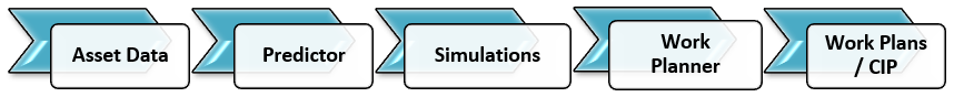
- Connection to Predictor: Seamlessly connect to Predictor simulations and generate GIS time series data representing assets and treatments. Export work plans back to Predictor and run simulations to determine the impact on long-term financial strategies.
- ArcGIS Pro Add-in: Take advantage of the GIS ecosystem to build work plans in reference to other GIS information, such as master plans and environmental constraints. Data relevant to projects and phases are captured as GIS data and exported to other formats to share capital investment plans and reports with internal and external stakeholders.
- Interactive Project Builder: Interactively bundle assets and treatments of multiple asset types from Predictor into projects and phases within a rich GIS environment. Override Predictor treatments and costs, moving treatments to different years, balance project funding across multiple funding sources, and more.
- Intuitive Project Insights: Visualize projects and phases within the work plan on a tile-based dashboard as well as grid-based, drag and drop project cards to balance budgets and prioritize and sequence phases with real-time feedback across funding sources and plan years.
- Grid View: Sort, filter and export information quickly to meet reporting and analytics needs across various business intelligence tools.
- Configurable Settings: Set up work plans with flexible configuration options for funding sources, status values, priority values, project fields and more.
- Multi-User Support: Allow real-time collaboration between planning stakeholders to work on work plans and see what others are doing as project and GIS data are automatically updated.
Key Users of Work Planner Module
Any organization that uses Predictor as part of its strategic asset management process will benefit from using the Work Planner module for work and capital investment planning. The module is designed for infrastructure project managers, project planners, asset planners and engineers who can benefit from using GIS in the planning process.
Work Planner Interaction with Predictor
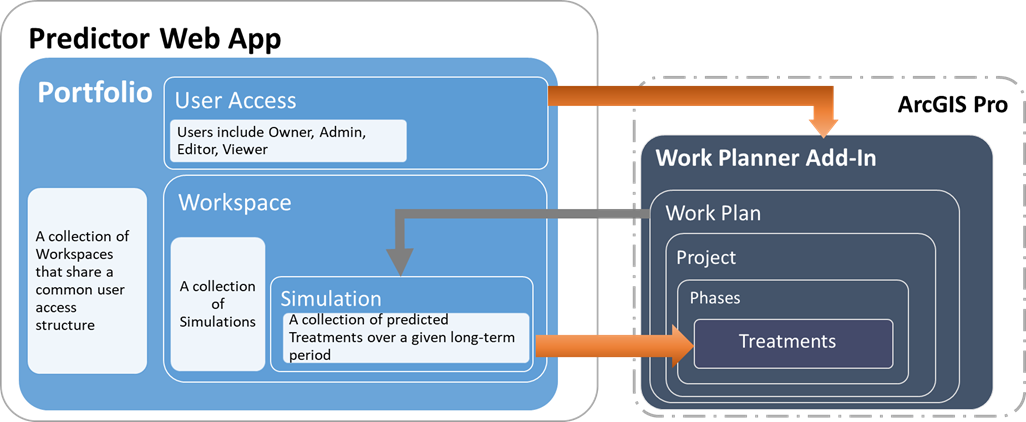
As shown in the following image, the key integration points between Predictor and Work Planner are the User Access and the Simulation components. The Predictor Web App provides the user management and licensing framework for Work Planner.
Furthermore, Work Planner provides the ability to export "Force Rules" that it generates from a work plan back to the Predictor Desktop.
Definitions and Terms
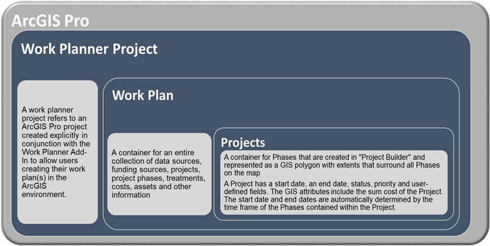
- Work Planner: A module for Predictor that is an ArcGIS Pro Add-in.
This module enables users to select assets and treatments from Predictor simulations (data sources) on a map and bundle them into Projects and Phases. It also allows users to allocate funds to each project phase from user-defined funding sources. - ArcGIS Pro Project: As defined by Esri, an ArcGIS Pro Project is a collection of related items—maps, layouts, tables, charts, data connections, and more—that contribute to a common purpose. An ArcGIS Pro Project stores all the GIS-related items and settings (such as layer colors) for Work Planner
- Work Plan: A container for an entire collection of data sources, funding sources, projects, project phases, treatments, costs, assets and other information.
- Work Planner Project: A container for Phases that are created in Builder and represented as a GIS polygon with extents that surround all Phases on the map.
A Project has a start date, an end date, status, priority and user-defined fields. The GIS attributes include the sum cost of the Project. The start date and end dates are automatically determined by the time frame of the Phases contained within the Project. - Phase: A container for Treatments that are created in "Project Builder" and represented as a GIS polygon on the map.
A Phase has a start date, an end date, status, priority and user-defined fields. The Phase's GIS attributes include the sum cost of the Phase and the name of the parent Project. The user sets the timeframe of each Phase. - Treatment: An action on an asset associated with a cost originating from a Predictor simulation
The cost is calculated from the unit cost variation originating from Predictor. Users may edit and override the treatment and the cost that is created from Predictor using the available list of Treatments and their cost variations. - Force Rule: In practice, the Work Planner user likely moves a treatment from Predictor's proposed year to another year in order to bundle the treatments efficiently. Also, users may evaluate and add some assets that are not selected by Predictor for treatment to a project of the same proximity. Any changes/addition to the original treatment type, cost, and year from what proposed by Predictor (through input simulations) as a result of the planning in the Work Planner is called a "Force Rule."
- Data Source: A collection of asset attributes, asset treatments and asset's associated spatial data.
Each record in the Data Source for treatments must include fields for Asset ID, Treatment Name, Treatment Date, Treatment Cost and Asset Name. When the imported simulation is not in spatial format, the associated spatial data source in GeoJSON format must at least include fields for Asset ID and Asset Name. - Simulation: The most common Data Source for Work Planner. Originating from Predictor, a Simulation contains all the information for each asset regarding its service state, treatment filter values, extra mapping values, treatments and costs for every year of the simulation. The data imported to Work Planner includes Treatment Name, Treatment Date, Treatment Cost and Asset Name.
- Project Layers: Work Planner creates a time enabled Treatment Feature Layer and an Asset Feature Layer in ArcGIS Pro when a Data Source is imported. The time enabled Treatment Feature Layer contains GIS features for each treatment (implying that if two treatments are applied to an asset at different times, then two features for that asset will be created). The Asset Feature Layer contains GIS features for each asset, regardless if it receives treatments or not. Work Planner works with these layers transparently so that most users do not need to be concerned with managing them.
- Members / Users (Work Plan): Identical in function to the Predictor's Portfolio Members, at a Work Plan level.
The following graphic shows the containment relationship of the Work Planner module inside ArcGIS Pro.